These 10 classic treks are for serious walkers. All of them require a sturdy pair of lungs, fit legs and a good amount of preparation. However, if you choose to go on any of these trails then you will be rewarded with experiences that last a lifetime. In no particular order:
1. GR20, France
2. Inca Trail, Peru
3. Pays Dogon, Mali
4. Everest Base Camp, Nepal
Reaching a height of 5,545m (18,193ft) at Kala Pattar, this three-week trek is extremely popular with those who want to be able to say, ‘I’ve been to the base of the world’s highest mountain’. The difficult trek passes undeniably spectacular scenery and is trafficked by Sherpa people of the Solu Khumbu. The heights reached during this trek are literally dizzying until you acclimatise to the altitude, and the continuous cutting across valleys certainly has its ups and downs.
5. Indian Himalayas, India
Trekking & Mountaineering in Team Because of the vastness of the terrain and altitude difference, trekking trips can be undertaken the whole year round. Treks range from low altitude treks in winter to the crossing of high passes in summer when the snow line recedes. It is also possible to combine all three-river running, trekking and mountaineering. The conventional trekking periods preferred are mid-April to May-June before the monsoon and after the rains in the months of September - November.
6. Overland Track, Australia
7. Routeburn Track, New Zealand
It traverses the Southern Alps (Kā Tiritiri o te Moana) of New Zealand and passes through ice-carved valleys and beech forest. Walk alongside pristine rivers and glistening alpine lakes offering breathtaking views and mountain scenery.
8. The Narrows, USA
Hiking The Narrows means hiking in the Virgin River. At least 60 percent of the hike is spent wading, walking, and sometimes swimming in the river. There is no maintained trail because the route is the river. The current is swift, the water is cold, and the rocks underfoot are slippery.
Flash flooding and hypothermia are constant dangers. Good planning, proper equipment, and sound judgment are essential for a safe and successful trip. Your safety is your responsibility.
A permit is required for the 16-mile top-down hike through The Narrows. A permit is not required for hiking The Narrows from the bottom up.
9. The Haute Route, France-Switzerland
The route traverses below the summits of ten out of the twelve of the highest peaks in the Alps, and crosses several high passes. The highest pass is at 2964m (9,800ft).
This is a world of glaciers and towering, snow-capped peaks. The route also meanders through green alpine valleys with flower-covered meadows and picture-book villages. A trek of contrasts.
The route passes through the centre of both the French and Swiss Alps: two distinct cultural regions with different languages and architecture.
This is a remote trek. Take a tent or sleep in a mountain hut or a refuge. One or two nights could be spent in valley hotels to catch up on those hot showers.
Zermatt is probably one of the most beautiful alpine villages in the world. Nestled just beneath the famous East face of the Matterhorn, the village is at 1600m (5,250 ft). Cars are not allowed in the village so the air is always clean and the streets quiet.
10. Baltoro Glacier & K2, Pakistan
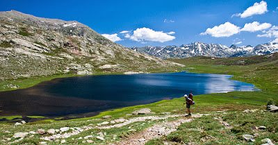
1. GR20, France
Image by Jean-Baptiste Bellet
This demanding 15- day (168km, 104mi) slog through Corsica is legendary for the diversity of landscapes it traverses. There are forests, granite moonscapes, windswept craters, glacial lakes, torrents, peat bogs, maquis, snow-capped peaks, plains and névés (stretches of ice formed from snow). But it doesn’t come easy: the path is rocky and sometimes steep, and includes rickety bridges and slippery rock faces – all part of the fun. Created in 1972, the GR20 links Calenzana, in the Balagne, with Conca, north of Porto Vecchio.2. Inca Trail, Peru
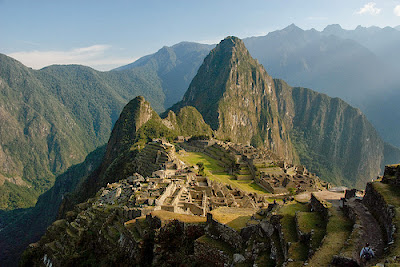
Image by funkz
This 33km (20mi) ancient trail was laid by the Incas and is currently traversed by thousands each year. The trail leads from the Sacred Valley to Machu Picchu winding its way up and down and around the mountains, taking three high passes en route. Views of white-tipped mountains and high cloud forest combine with the magic of walking from one cliff-hugging ruin to the next – understandably making this South America’s most famous trail.3. Pays Dogon, Mali
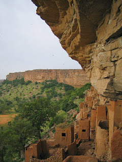
Image by Crazy Joe Devola
‘The land of the Dogon people’ is one of Africa’s most breathtaking regions. A trek here can last anywhere between two and 10 days, and takes in the soaring cliffs of the Bandiagara escarpment inlaid with old abandoned cliff dwellings. Dogon villages dot the cliffs and are an extraordinary highlight of the journey. The Dogon are known for their masked stilt dancers, intricately carved doors and pueblo-like dwellings built into the side of the escarpment.4. Everest Base Camp, Nepal
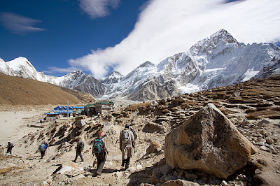
Reaching a height of 5,545m (18,193ft) at Kala Pattar, this three-week trek is extremely popular with those who want to be able to say, ‘I’ve been to the base of the world’s highest mountain’. The difficult trek passes undeniably spectacular scenery and is trafficked by Sherpa people of the Solu Khumbu. The heights reached during this trek are literally dizzying until you acclimatise to the altitude, and the continuous cutting across valleys certainly has its ups and downs.
Image by lampertron
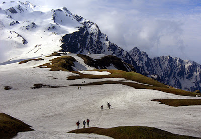
5. Indian Himalayas, India
Image by Chandramohan Burly V
Fewer folk trek on the Indian side of the world’s greatest mountain range. So, if isolation’s your thing try trekking in Himachal Pradesh. Hardcore hikers can try teetering along the mountain tops for 24 days from Spiti to Ladakh. This extremely remote and challenging walk follows ancient trade routes. The bleak high-altitude desert terrain inspired Rudyard Kipling to exclaim, ‘Surely the gods live here; this is no place for men’.Trekking & Mountaineering in Team Because of the vastness of the terrain and altitude difference, trekking trips can be undertaken the whole year round. Treks range from low altitude treks in winter to the crossing of high passes in summer when the snow line recedes. It is also possible to combine all three-river running, trekking and mountaineering. The conventional trekking periods preferred are mid-April to May-June before the monsoon and after the rains in the months of September - November.
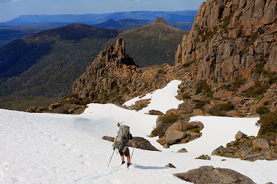
6. Overland Track, Australia
Image by brewbooks
Tasmania’s prehistoriclooking wilderness is most accessible on the 80km (50mi, five- to six-day) Overland Track. Snaking its way between Cradle Mountain and Lake St Clair (Australia’s deepest natural freshwater lake), the well-defined path (boardwalked in parts) passes craggy mountains, beautiful lakes and tarns, extensive forests and moorlands. Those who want more can take numerous side walks leading to waterfalls, valleys and still more summits including Mt Ossa (1,617m, 5,305ft) – Tassie’s highest.7. Routeburn Track, New Zealand
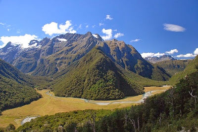
Image by kiwinz
See the stunning subalpine scenery of New Zealand’s South Island surrounding this medium three-day (32km, 20mi) track. At the base of New Zealand’s Southern Alps, the track passes through two national parks: Fiordland and Mt Aspiring. Highlights include the views from Harris Saddle and atop Conical Hill – from where you can see waves breaking on the distant beach. The main challenge for this popular hike is actually securing a place among the limited numbers who are allowed on the track at any time.It traverses the Southern Alps (Kā Tiritiri o te Moana) of New Zealand and passes through ice-carved valleys and beech forest. Walk alongside pristine rivers and glistening alpine lakes offering breathtaking views and mountain scenery.
8. The Narrows, USA
Image by Adam Belles
The Virgin River has carved a spectacular gorge in the upper reaches of Zion Canyon: 16 miles long, up to 2,000-feet deep, and at times only 20 to 30-feet wide. The Narrows, with its soaring walls, sandstone grottos, natural springs, and hanging gardens can be an unforgettable wilderness experience. However, it is not a hike to be underestimated.Hiking The Narrows means hiking in the Virgin River. At least 60 percent of the hike is spent wading, walking, and sometimes swimming in the river. There is no maintained trail because the route is the river. The current is swift, the water is cold, and the rocks underfoot are slippery.
Flash flooding and hypothermia are constant dangers. Good planning, proper equipment, and sound judgment are essential for a safe and successful trip. Your safety is your responsibility.
A permit is required for the 16-mile top-down hike through The Narrows. A permit is not required for hiking The Narrows from the bottom up.
9. The Haute Route, France-Switzerland
Image by perry_maurice
This is a spectacular and demanding summer hike: a strenuous high-level traverse in the French and Swiss Alps, walking from Chamonix in France to Zermatt in Switzerland in 10 to 12 days.The route traverses below the summits of ten out of the twelve of the highest peaks in the Alps, and crosses several high passes. The highest pass is at 2964m (9,800ft).
This is a world of glaciers and towering, snow-capped peaks. The route also meanders through green alpine valleys with flower-covered meadows and picture-book villages. A trek of contrasts.
The route passes through the centre of both the French and Swiss Alps: two distinct cultural regions with different languages and architecture.
This is a remote trek. Take a tent or sleep in a mountain hut or a refuge. One or two nights could be spent in valley hotels to catch up on those hot showers.
Zermatt is probably one of the most beautiful alpine villages in the world. Nestled just beneath the famous East face of the Matterhorn, the village is at 1600m (5,250 ft). Cars are not allowed in the village so the air is always clean and the streets quiet.
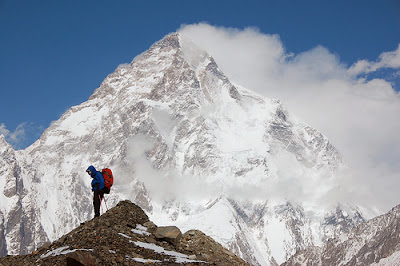
10. Baltoro Glacier & K2, Pakistan
Image by mariachily
This corridor of ice leads to the colossal peak of K2 (8,611m, 28,251ft), the world’s second-highest peak. This incomparable trek traverses some of the most humbling scenery on the planet. What begins following icy rivers boldly goes to the guts of the glacier before leading to the granite pyramidal mountains including Paiju (6,610m, 21,686ft), Uli Biaho (6,417m, 21,053ft), Great Trango Tower (6,286m, 20,623ft) and ultimately K2. If the 15 days doesn’t floor you, take side trips to more moraine-covered glaciers.Mountain Summits ::
Continent | Highest Mountain Summit | Second Highest Mountain Summit | Third Highest Mountain Summit |
5,895 (19,341 ft) | 5,199 (17,057 ft) | 5,149 m (16,893 ft) | |
4,897 (16,500 ft) | 4,852 (15,919 ft) | 4,661 m (15,292 ft) | |
4,884 (16,024 ft) | 4,760 (15,617 ft) | 4,750 m (15,584 ft) | |
8,848 (29,029 ft) | 8,611 (28,251 ft) | 8,586 m (28,169 ft) | |
5,642 (18,510 ft) | 5,205 (17,076 ft) | 5,193 m (17,037 ft) | |
Mount McKinley – USA(Alaska) 6,194 (20,320 ft) | 5,959 (19,550 ft) | 5,636 m (18,491 ft) | |
6,962 (22,841 ft) | 6,893 (22,614 ft) | 6,793 m (22,287 ft) |
Himalayan Ranges ::
Image | Name | Elevation m | Country | Range | Parent Range | Continent |
8,848 | ||||||
8,611 | Pakistan-China | Himalayas | Asia | |||
8,586 | Nepal-India | Himalayas | Asia | |||
8,516 | Nepal-China | Mahalangur Himalayas | Himalayas | Asia | ||
8,463 | Nepal-China | Mahalangur Himalayas | Himalayas | Asia | ||
8,201 | Nepal-China | Mahalangur Himalayas | Himalayas | Asia | ||
8,167 | Nepal | Himalayas | Asia | |||
8,163 | Nepal | Himalayas | Asia | |||
8,125 | Pakistan | Himalayas | Asia | |||
8,091 | Nepal | Himalayas | Asia | |||
8,068 | Pakistan-China | Karakoram | Himalayas | Asia | ||
8,047 | Pakistan-China | Karakoram | Himalayas | Asia | ||
8,035 | Pakistan-China | Karakoram | Himalayas | Asia | ||
8,012 | China | Himalayas | Asia |
Article Source :: Lonely Planet
